Flights in the southern hemisphere on a flat Earth
Maps · Updated
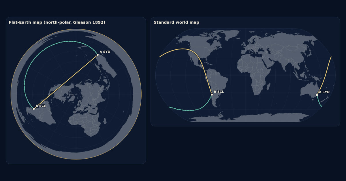
On Gleason’s north-polar flat Earth map, direct routes between southern continents are more than twice as long as on the globe: Sydney to Santiago is 25,660 km, against 11,340 km. Qantas QF27 is scheduled at about 12 h 30 min, so the flat map would need about 2,050 km/h on average and the globe about 910 km/h. The Flat Earth Society points to winds and routing.
Astronomy and geodesy describe the Earth as a slightly flattened sphere about 12,742 km across, with the Sun about 150 million km away (NASA: Earth facts). FlatAtlas shows the published flat-Earth models next to that, so you can compare both with what you see.
How far apart are southern cities on the flat Earth map?
On the north-polar map every distance from the North Pole is true, but east–west distances grow south of the Equator. Routes between southern continents come out two to two and a half times longer than on the globe. Northern routes, such as Perth to London, change much less.
| Route | Flat map | Globe | Ratio |
|---|---|---|---|
| Sydney–Santiago | 25,660 km | 11,340 km | 2.26× |
| Auckland–Santiago | 23,390 km | 9,650 km | 2.42× |
| Auckland–Buenos Aires | 25,010 km | 10,310 km | 2.42× |
| Sydney–Johannesburg | 23,440 km | 11,020 km | 2.13× |
| Perth–Johannesburg | 18,340 km | 8,310 km | 2.21× |
| Johannesburg–São Paulo | 15,480 km | 7,440 km | 2.08× |
| Perth–London (northern comparison) | 15,920 km | 14,510 km | 1.10× |
Try any route, with stopovers, in the flat Earth flight calculator.
Which direct flights cross the southern hemisphere?
Several nonstop flights are in the filed airline schedules for late 2026: Qantas QF27/QF28 and LATAM between Sydney and Santiago, LATAM LA800/LA801 between Auckland and Santiago, China Eastern MU745/MU746 between Auckland and Buenos Aires, Qantas QF63/QF64 between Sydney and Johannesburg, Qantas QF65/QF66 and South African Airways between Perth and Johannesburg, and South African Airways between Johannesburg and São Paulo.
What average speed does each map need?
| Flight | Scheduled | Speed, flat map | Speed, globe |
|---|---|---|---|
| QF27 Sydney–Santiago | 12 h 30 min | 2,050 km/h | 910 km/h |
| LA800 Auckland–Santiago | 11 h 00 min | 2,130 km/h | 880 km/h |
| MU745 Auckland–Buenos Aires | 11 h 50 min | 2,110 km/h | 870 km/h |
| QF63 Sydney–Johannesburg | 14 h 40 min | 1,600 km/h | 750 km/h |
| QF65 Perth–Johannesburg | 11 h 15 min | 1,630 km/h | 740 km/h |
| QF9 Perth–London | 17 h 40 min | 900 km/h | 820 km/h |
Speed is the distance divided by the scheduled block time, gate to gate, so the speed in the air is a little higher. Long-haul airliners usually cruise at about 900 km/h, and wind adds or removes a few hundred km/h. The return flights take longer: QF28 from Santiago to Sydney is scheduled at about 14 h 30 min, against the prevailing westerly winds.
How does the Flat Earth Society explain southern flights?
The Flat Earth Wiki says flight data is hard to use as evidence: “The shortest geographical route is often not taken, and changes by the day. Non-stop flights are not necessarily always non-stop”, and listed flight times “are purposely skewed by large amounts”. About the few nonstop southern flights, it says that some “question their existence or accuracy”, and that “Others suggest that the flights which do travel directly in the South may be taking advantage of jet streams and abnormal wind conditions that are known to exist in the South.”
The wiki also describes a second map. In the classic monopole map used here, east–west distances “diverge” south of the Equator; in its Bi-Polar model, with Antarctica as a continent, they “converge”, as on the globe. It calls its map “a proposed, but certainly not definitive, Flat Earth”.
What about flights with stopovers?
The wiki notes that many trips between southern continents go through the north with one or more stops, and that such routes “tend to curiously straighten out on the Monopole Map”. In the calculator you can add every stop and compare each leg on both maps, for example Johannesburg–Dubai–Perth against the nonstop Perth–Johannesburg.
How can you check it yourself?
Pick a nonstop southern flight, look up its schedule, and follow it live on a flight tracker such as Flightradar24 or FlightAware, which show the position and the ground speed. Enter the airports and the time in the flat Earth flight calculator and compare both maps with what the tracker shows.
Frequently asked questions
How far is Sydney to Santiago on a flat Earth?
About 25,660 km in a straight line on Gleason's north-polar flat Earth map, against 11,340 km on the globe. Qantas QF27 is scheduled at about 12 h 30 min.
Are there direct flights between southern continents?
Yes, a few are scheduled nonstop, for example Qantas QF27 Sydney–Santiago, QF63 Sydney–Johannesburg, QF65 Perth–Johannesburg, LATAM LA800 Auckland–Santiago and China Eastern MU745 Auckland–Buenos Aires.
How does the Flat Earth Society explain southern flights?
The Flat Earth Wiki says flight data is hard to use as evidence, that listed flight times may be skewed and nonstop flights may stop, and that direct southern flights may use jet streams and abnormal southern winds. Its Bi-Polar model gives shorter southern distances.
Sources
- FlightMapper: filed airline schedules (Qantas QF27/QF28, QF63, QF65, LATAM LA800, China Eastern MU745, South African SA222, Qantas QF9)
- The Flat Earth Wiki: Issues in Flight Analysis
- The Flat Earth Wiki: Flight Anomalies
- The Flat Earth Wiki: Southern Hemisphere
- The Flat Earth Wiki: Distances in the South
- Gleason’s New Standard Map of the World (1892), Leventhal Map & Education Center
- OurAirports: airport coordinates