Interactive 3D flat Earth map and simulator
Updated
FlatAtlas is a free 3D flat Earth map and simulator. It places the Sun, the Moon and the planets above the map at the heights published by the Flat Earth Society and by Samuel Rowbotham, and shows where astronomy puts the same bodies for your place and time. Compare the flat Earth model with the real sky, check it yourself, and make up your own mind.
Astronomy and geodesy describe the Earth as a slightly flattened sphere about 12,742 km across, with the Sun about 150 million km away (NASA: Earth facts). FlatAtlas shows the published flat-Earth models next to that, so you can compare both with what you see.
Open the 3D map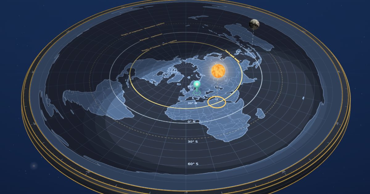
How high is the Sun on a flat Earth?
According to the Flat Earth Society, the Sun is about 3,000 miles (4,800 km) above the flat Earth and about 32 miles (51 km) across. Samuel Rowbotham’s Zetetic Astronomy (1881) puts it 700 miles (1,100 km) up. FlatAtlas shows both heights in 3D above the same map, next to where astronomy puts the Sun right now.
Flat Earth Sun height: sources and maths →
| Flat Earth model | Sun | Moon | Planets |
|---|---|---|---|
| Flat Earth Society | about 3,000 mi (4,800 km) | “several thousand miles”; drawn at 2,000 mi (3,200 km) | no figure; drawn on their own levels above the Sun, 5,900–10,700 km |
| Samuel Rowbotham, 1881 | 700 mi (1,100 km) | “nearer than the Sun”; drawn at 700 km | within 1,000 mi; drawn at 1,300–1,600 km |
How far away is the Moon on a flat Earth?
The Flat Earth Wiki gives the Moon the same size as the Sun, about 32 miles across, and places it “several thousand miles” above the Earth. Rowbotham wrote only that the Moon is “nearer than the Sun”. Both explain a solar eclipse by the Moon passing below the Sun, so FlatAtlas draws it lower: 3,200 km (2,000 miles) in the Flat Earth Society model.
How Moon phases work on a flat Earth →
Why does the Sun set on a flat Earth?
Rowbotham explained sunset by perspective: a body vanishes at the horizon once it is less than one minute of arc above it. FlatAtlas applies this rule to your place. From Bratislava no point of the map is farther than about 24,650 km, so by this rule a Sun 4,800 km up would stay at least 11° above the horizon.
Sunset on a flat Earth: 10 cities compared →
The Flat Earth Wiki also describes Electromagnetic Acceleration, light that bends upwards so a distant Sun appears to set, but publishes no figures that could be calculated.
How big is the Sun in the flat Earth model?
The Flat Earth Society gives the Sun a diameter of about 32 miles (51 km). A Sun that size, 4,800 km up, would look about 0.6° wide overhead. Seen from Bratislava, it would shrink to about a fifth of that at the farthest point of the map. The real Sun looks about 0.5° wide all day, from sunrise to sunset. The Flat Earth Wiki explains this by a magnification of the Sun at sunset, without figures that could be calculated.
What is the flat Earth map? Azimuthal equidistant projection
The usual one is a north-polar azimuthal equidistant projection: the North Pole in the centre, true distances from it, and Antarctica stretched into the rim. It is the layout of Alexander Gleason’s New Standard Map of the World (1892), about 40,000 km across. FlatAtlas adds optional layers for time zones, the Sun’s daily path between the tropics, and Gleason’s 24-hour ring.
How distances change on Gleason’s projection → · Antarctica and the ice wall →
Flat Earth vs globe: what can you check yourself?
You can compare a flat Earth model with the globe by checking three things in the real sky: where the Sun is now, how big it looks, and whether it sets. FlatAtlas calculates what the Flat Earth Society model predicts for each and shows what astronomy predicts for the same moment, so you can compare both with what you see.
Five things to check yourself → · Earth curvature calculator → · The Bedford Level experiment →
| What to check | Flat Earth model (FES, from Bratislava) | Astronomy |
|---|---|---|
| Direction and height of the Sun now | calculated from the map and the 4,800 km height | calculated by Astronomy Engine |
| Apparent size of the Sun | about 0.6° overhead, smaller farther away | about 0.5° all day |
| Lowest the Sun can go (1′ perspective rule) | at least 11° above the horizon | sets below the horizon |
Both sides are calculated, not observed: the point of FlatAtlas is that you go outside and look.
How does FlatAtlas work?
- Pick your place. FlatAtlas finds your local time and time zone.
- Choose a flat Earth model: the Flat Earth Society, Samuel Rowbotham (1881), or your own heights.
- Check it in the sky. See the direction and angle above the horizon where the model puts the Sun or Moon, next to where astronomy puts it. Then look outside.
How FlatAtlas calculates the flat Earth model
Positions of the Sun, the Moon and the planets come from Astronomy Engine, with parallax and standard refraction, so you can check them against any almanac. Each body stands above the point on Earth where it is directly overhead; the flat Earth model only sets how high it floats above that point, and it never moves the bodies.
The angle at which you would see a body in the model is the arctangent of its height divided by its distance from you across the disc. The map is 40,000 km across, as on Gleason’s map. Heights come only from the published sources listed below.
Can you follow real flights on the flat Earth?
Yes. The FlatAtlas Flight simulator flies five real flights from the flat Earth debate in 3D, such as Qantas QF27 Sydney–Santiago and Emirates via Dubai to Perth, with the time in the air taken from Flightradar24 records. It shows the Model route on the flat Earth next to the route the flight took, on a globe. Open the Flight simulator or see the figures in the Flat Earth flight calculator.
Is FlatAtlas free?
Yes. The 3D map with the Sun and the Moon, “Check it in the sky”, the height models, the map layers and the Flight simulator with five real flights are free. FlatAtlas Pro is a one-time payment of USD 24.99 (USD 14.99 until 31 December 2026) that adds every planet, the sky dome, the realistic Earth surface, a time machine, saved observations and your own flights with stopovers. See pricing.
Sources
- The Flat Earth Wiki: Distance to the Sun
- The Flat Earth Wiki: The Moon
- The Flat Earth Wiki: Sunrise and Sunset
- S. B. Rowbotham, Zetetic Astronomy, 3rd edition (1881): The True Distance of the Sun
- Gleason’s New Standard Map of the World (1892), Leventhal Map & Education Center
- Astronomy Engine
Flat Earth guideEvidence LabFlat Earth flight calculatorEarth curvature calculatorAboutPricingTerms of ServicePrivacy PolicyRefund policysupport@flatatlas.app