The Eratosthenes experiment: flat Earth or globe?
Measure the Sun’s angle in two cities at the same moment. On a flat Earth the two angles give the Sun’s height; on a globe they give the Earth’s size. Eratosthenes’ figures, 7.2° over about 800 km, give a Sun about 6,330 km high or a globe about 40,000 km around. A third city tests both readings at once.
Astronomy and geodesy describe the Earth as a slightly flattened sphere about 12,742 km across, with the Sun about 150 million km away (NASA: Earth facts). FlatAtlas shows the published flat-Earth models next to that, so you can compare both with what you see.
Evidence map
Cited by flat Earth supporters
Eratosthenes' stick experiment can not only tell us about the size of the earth, but can also be used to compute the distance to the sun as well.
At Aswan the Sun stands almost overhead at noon on the June solstice
Flat Earth model
89.1°
In the Flat Earth Society model the Sun circles 4,800 km above the map and is over the Tropic of Cancer at the June solstice, so it is nearly overhead at Aswan.
Globe
89.3°
On the globe the Sun is overhead at 23.4° N at the June solstice; Aswan lies 0.7° farther north.
Observed
No independent record yet
At local noon an upright stick casts almost no shadow at Aswan. Shadow length divided by stick height is the tangent of the Sun’s angle from overhead.
You can check it yourselfAt the same moment the Sun is lower at Alexandria, about 800 km to the north
Flat Earth model
78.9°
Alexandria is farther from the point under the Sun on the map; with the Sun 4,800 km up, the sight line is lower.
Globe
81.8°
On the globe the ground at Alexandria is tilted by its 7.1° greater latitude, so the Sun appears lower.
Observed
No independent record yet
Two people with upright sticks measure their shadows at the same agreed moment in UTC and each work out their own angle.
You can check it yourselfJohannesburg, about 5,600 km south of the point under the Sun, sees the Sun in the northern sky
Flat Earth model
40.7°
On the map Johannesburg is about 5,600 km from the point under the Sun; the Sun’s height and that distance set the angle.
Globe
40.2°
On the globe Johannesburg lies 49.6° of latitude from the point under the Sun, which sets the angle.
Observed
No independent record yet
The same stick and shadow at noon in Johannesburg, on the same day and minute in UTC.
You can check it yourself
Evidence and data quality
- You can check it yourself Both A stick, a tape measure and a friend in another city at the same moment in UTC: the method needs no special equipment.
- Single report Both Wikipedia: Eratosthenes: Eratosthenes’ measurement (about 240 BC), known from Cleomedes: the noon Sun overhead at Syene and 1/50 of a circle from overhead at Alexandria.
- Calculation from a model Flat Earth model The Flat Earth Wiki: Distance to the Sun: The Sun’s height in the Flat Earth Society model.
- Calculation from a model Globe Astronomy Engine (Sun and Moon positions): The Sun’s position for any place and time on the globe; FlatAtlas uses it for every globe figure.
Data quality says how a figure was obtained, on the same scale for both sides. It does not rate which model is right.
Run the test
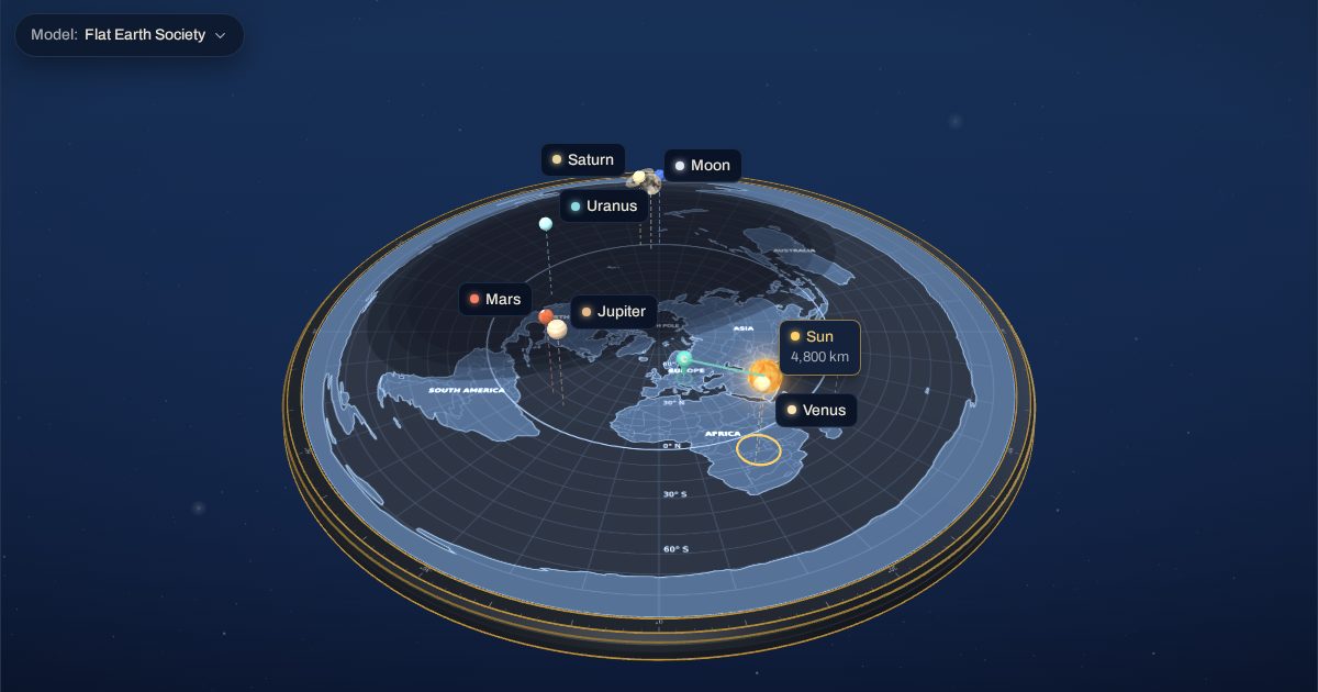
The same 3D model as the FlatAtlas app, set to 21 June 2026 at 09:50 UTC with the Flat Earth Society heights. Switch the observer between the places and follow the sight line to the Sun.
Try your own two angles
Flat Earth model: the Sun’s height
Globe: the Earth’s circumference
Both readings assume the two places lie on one line towards the point under the Sun, on the same side of it (north–south at noon). Eratosthenes’ figures are filled in.
What do two Sun angles tell you?
Two angles measured at the same moment can be read two ways. Over a flat Earth they place the Sun at a height above the map: the farther a place is from the point under the Sun, the lower its sight line. On a globe the Sun is so far away that its rays arrive parallel, and the difference in angle is the difference in latitude between the places.
What does a third city add?
With two cities both readings work. A third city gives a second pair. Over a flat Earth each pair gives a Sun height; on a globe each pair gives a size for the Earth. The evidence map above lists the angle each model predicts for all three cities at the same moment, so you can compare them with a measurement of your own.
Frequently asked questions
What did Eratosthenes measure?
According to Cleomedes, he compared the noon Sun at Syene (Aswan), where it stood overhead, with Alexandria, where it was 1/50 of a circle (7.2°) from overhead. On a globe that gives the Earth’s size; on a flat Earth the same figures give the Sun’s height.
Can I do the test myself?
Yes. Agree on a moment in UTC with someone in another city, stand sticks upright and measure the shadows. Enter both angles and the distance in the form on this page to see both readings side by side.
Why does FlatAtlas use 4,800 km for the Sun?
It is the Flat Earth Society wiki’s figure (about 3,000 miles, Distance to the Sun). The Rowbotham 1881 model puts the Sun at about 1,100 km; you can switch models in the 3D app.