Midnight sun in Antarctica: flat Earth vs globe
Around the December solstice the Sun stays above the horizon all day at Davis Station in Antarctica, and on the same day it stays below the horizon at noon in Longyearbyen, Svalbard. On the north-polar flat Earth map Antarctica is the outer rim, and in December the Sun circles above the Tropic of Capricorn. The evidence map shows what each model gives for both places.
Astronomy and geodesy describe the Earth as a slightly flattened sphere about 12,742 km across, with the Sun about 150 million km away (NASA: Earth facts). FlatAtlas shows the published flat-Earth models next to that, so you can compare both with what you see.
Evidence map
Cited by globe supporters
Globe supporters cite the midnight sun in Antarctica: on the flat Earth map Antarctica lies on the outer rim, so at local midnight in December the Sun, circling above the Tropic of Capricorn, is on the far side of the map.
Source: Metabunk: Antarctica thread
At Davis Station the Sun is above the horizon at local midnight on the December solstice
Flat Earth model
9.0°
In the Flat Earth Society model the Sun is then on the far side of the map, about 30,000 km from Davis, and the sight line to it rises about 9°. The model explains day and night by the spotlight effect: the Sun lights only part of the map at a time, and the wiki's Sun page gives no figure for how far its light reaches.
Source: The Flat Earth Wiki: Sun
Globe
2.3°
On the globe Davis lies south of the Antarctic Circle, so around the December solstice the Sun circles the sky without setting and is lowest, just above the horizon, at local midnight.
Observed
No independent record yet
Station webcams and photos taken at Davis around 21 December carry the time. Compare the Sun at local midnight, about 18:50 UTC, with both figures.
You can check it yourselfOn the December solstice the Sun does not set at Davis Station
Flat Earth model
No published figure
The Flat Earth Society describes sunset as the light of the Sun setting into the Flat Earth, explained by electromagnetic acceleration or by perspective. Neither gives a figure for when, or whether, the Sun sets at a given place.
Globe
24 h
On the globe the South Pole is tilted towards the Sun in December, so south of the Antarctic Circle the Sun stays above the horizon for the whole day.
Observed
No independent record yet
A time-lapse over one day at an Antarctic station shows whether the Sun touches the horizon.
You can check it yourselfOn the same day the Sun stays below the horizon at noon in Longyearbyen, Svalbard
Flat Earth model
23.0°
Longyearbyen is about 11,300 km from the point under the Sun on the map, and the sight line to it rises about 23°. In the Flat Earth Society model only part of the map is lit at a time, by the spotlight effect, and the wiki's Sun page gives no size for the lit area.
Source: The Flat Earth Wiki: Sun
Globe
-11.1°
On the globe Longyearbyen lies north of the Arctic Circle and is turned away from the Sun in December: the polar night.
Observed
No independent record yet
Svalbard webcams and photos from around 21 December show whether there is daylight at local noon, about 10:57 UTC.
You can check it yourself
Evidence and data quality
- Single report Flat Earth model The Flat Earth Wiki: Sun: The spotlight effect: the Sun's light covers a limited area of the map at a time, like the light of a lighthouse.
- Single report Flat Earth model The Flat Earth Wiki: Bi-Polar Model: An alternative flat Earth map with a south pole and Antarctica as a continent; the wiki notes that in it “beyond the rays of the sun the waters will naturally freeze”.
- Single report Both Wikipedia: Midnight sun: Where and when the Sun stays up at midnight, with photos from both polar regions.
- Single report Both Wikipedia: Polar night: Where and when the Sun stays below the horizon all day.
- Calculation from a model Globe Astronomy Engine (Sun and Moon positions): The Sun's position for any place and time on the globe; FlatAtlas uses it for every globe figure.
Data quality says how a figure was obtained, on the same scale for both sides. It does not rate which model is right.
Run the test
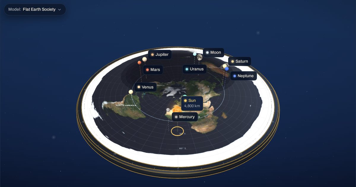
The same 3D model as the FlatAtlas app, set to 21 December 2026 at 18:48 UTC with the Flat Earth Society heights. Switch the observer between the places and follow the sight line to the Sun.
Why is the midnight sun cited in the flat Earth debate?
On the north-polar flat Earth map the South Pole is not a point: Antarctica is the outer rim of the disc. In December the Sun circles above the Tropic of Capricorn, so at local midnight it is on the far side of the map from any Antarctic station. On the globe the same stations are tilted towards the Sun all day.
What does the 3D test show?
The test is set to local midnight at Davis Station on the December solstice. Switch the observer between Davis, McMurdo and Longyearbyen and follow the sight line to the Sun across the map. The shading on the map is the globe's day and night drawn on FlatAtlas's Gleason map; the Flat Earth Society's spotlight effect has no published size, so the test does not draw it. The evidence map lists the angle each model gives, and where the flat Earth model gives no figure it says so.
Frequently asked questions
Does the Sun stay up all night in Antarctica?
Around the December solstice it does at stations south of the Antarctic Circle, such as Davis and McMurdo: the Sun is lowest at local midnight but stays above the horizon. Photos and webcams from the stations record it.
How does the flat Earth model explain it?
The Flat Earth Society wiki explains day and night by the spotlight effect, which limits the Sun's light to part of the map, and describes an alternative Bi-Polar model with Antarctica as a continent around a south pole. Neither gives a figure for the time of sunrise or sunset.
Can I check it myself?
Compare a time-stamped photo or webcam image from an Antarctic station near the December solstice with the angles on this page, or look at Svalbard in the same week. The 3D test shows Davis, McMurdo and Longyearbyen at the same moment.