Sunrise, sunset and time zones: flat Earth vs globe
Stockholm and Cape Town lie on almost the same longitude, 18° east. At the March equinox the Sun rises over both at about 04:50 UTC, within a minute of each other. The Flat Earth Society's Equinox page explains such a simultaneous sunrise by defining longitude through local time. Three months later, at the June solstice, the Sun sets at about 20:08 UTC in Stockholm and 15:45 UTC in Cape Town. The evidence map shows which figures each model gives.
Astronomy and geodesy describe the Earth as a slightly flattened sphere about 12,742 km across, with the Sun about 150 million km away (NASA: Earth facts). FlatAtlas shows the published flat-Earth models next to that, so you can compare both with what you see.
Evidence map
Cited by flat Earth supporters
If longitude is defined by local time and time zones then sunrise can occur for all observers simultaneously on the same longitude.
Source: The Flat Earth Wiki: Equinox
At the March equinox the Sun rises in Stockholm at about 04:50 UTC
Flat Earth model
No published figure
The Flat Earth Society's Equinox page describes a curved area of daylight on the flat map and defines longitude by local time, so that sunrise can come at once for everyone on one longitude. It gives no figure for the time of sunrise at a given place.
Source: The Flat Earth Wiki: Equinox
Globe
04:50 UTC
On the globe the Sun is over the equator at the equinox, so in both cities the day is a little over 12 hours (the atmosphere bends sunlight and adds a few minutes), and the sunrise line runs close to north–south, reaching both cities within a minute.
Observed
No independent record yet
Note the moment the top of the Sun appears over a flat or sea horizon on 20 March. Sunrise tables are a calculation on the globe, not a record.
You can check it yourselfOn the same morning the Sun rises in Cape Town, on almost the same longitude, within a minute of Stockholm
Flat Earth model
No published figure
The same Equinox page notes: “Points in a line radial from the North are not necessarily on the same longitude line.” In its terms the lines of longitude on the flat map are curved, following local time. It gives no figure for the time.
Source: The Flat Earth Wiki: Equinox
Globe
04:49 UTC
On the globe Cape Town lies on almost the same meridian as Stockholm, so at the equinox the Sun rises there at almost the same moment.
Observed
No independent record yet
Ask someone in a city on a similar longitude in the other hemisphere to time sunrise on the same morning.
You can check it yourselfAt the equinox the Sun is highest over Stockholm at about 10:55 UTC
Flat Earth model
10:55 UTC
On FlatAtlas's Gleason map noon is the moment the point under the Sun, taken from astronomy, crosses the place's meridian, so the figure is the same as on the globe.
Globe
10:55 UTC
On the globe the Earth's rotation turns Stockholm towards the Sun; it is highest when the Sun crosses the local meridian.
Observed
No independent record yet
Mark the shortest shadow of an upright stick and note the time: that is local noon.
You can check it yourselfAt the June solstice the Sun sets in Stockholm at about 20:08 UTC
Flat Earth model
No published figure
The Flat Earth Society describes sunset as the light of the Sun setting into the Flat Earth, explained by electromagnetic acceleration or by perspective. Neither gives a figure for the time of sunset at a given place.
Globe
20:08 UTC
On the globe Stockholm is tilted towards the Sun in June, so it stays in daylight for most of the Earth's turn: about 18 h 37 min from sunrise to sunset.
Observed
No independent record yet
Note the moment the top of the Sun disappears behind a flat or sea horizon on 21 June.
You can check it yourselfOn the same day the Sun sets in Cape Town more than four hours earlier, at about 15:45 UTC
Flat Earth model
No published figure
In the Flat Earth Society model the Sun lights only part of the map at a time, by the spotlight effect, and the Equinox page describes the area of daylight as curved. Neither page gives a figure for the time of sunset.
Source: The Flat Earth Wiki: Sun
Globe
15:45 UTC
On the globe Cape Town is tilted away from the Sun in June, so its day is about 9 h 54 min long.
Observed
No independent record yet
The same horizon watch in Cape Town on 21 June; compare the two times.
You can check it yourself
Evidence and data quality
- Single report Flat Earth model The Flat Earth Wiki: Equinox: Longitude defined by local time, curved time zones and a curved area of daylight on the flat map.
- Single report Flat Earth model The Flat Earth Wiki: Electromagnetic Acceleration: Electromagnetic acceleration as the mechanism of sunrise and sunset.
- You can check it yourself Both A clear horizon, a stick for noon and a friend in the other city: the times can be compared on the same day.
- Calculation from a model Globe Astronomy Engine (Sun and Moon positions): Sunrise, noon and sunset for any place and date on the globe.
Data quality says how a figure was obtained, on the same scale for both sides. It does not rate which model is right.
Run the test
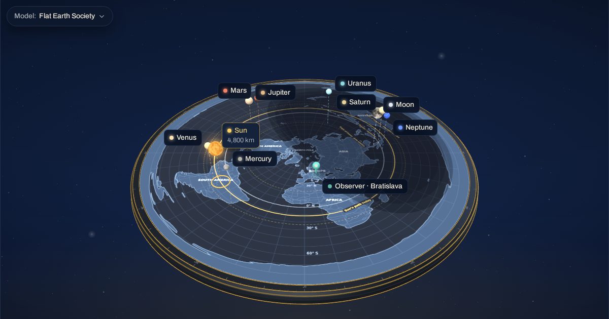
The same 3D model as the FlatAtlas app, set to 20 March 2026 at 04:50 UTC with the Flat Earth Society heights. Switch the observer between the places and follow the sight line to the Sun.
Why are time zones cited in the flat Earth debate?
Time zones follow longitude: every 15° is one hour. On Gleason's north-polar map, which FlatAtlas uses, the meridians run straight out from the North Pole. The Flat Earth Society's Equinox page instead defines longitude by local time, which makes its lines of longitude curved, and explains with it why sunrise at the equinox comes at once along one longitude. The same two cities can then be compared at a solstice, when their days differ by hours.
What does the 3D test show?
The test is set to 04:50 UTC on the March equinox, the moment of sunrise in Stockholm and Cape Town. Switch the observer between the two cities and follow the sight line to the Sun. The shading on the map is the globe's day and night drawn on FlatAtlas's Gleason map: at the equinox its edge runs straight along the meridian through both cities. The Flat Earth Society's Equinox page draws a curved area of daylight with curved lines of longitude and gives no size for it, so the test does not show that version. The evidence map lists the times each model gives, and where the flat Earth model gives no figure it says so.
Frequently asked questions
What does the Flat Earth Society say about time zones?
Its Equinox page defines longitude by local time. On a flat map with a curved area of daylight, that makes the lines of longitude and the time zones curved, so that sunrise can come at once for everyone on one longitude.
Why does the Sun set hours apart in the two cities in June?
On the globe the tilt of the Earth's axis gives the northern hemisphere long days in June and the southern hemisphere short ones. The Flat Earth Society explains sunset by electromagnetic acceleration or perspective and describes a curved area of daylight on the map, without a figure for the time.
Can I check it myself?
Yes. Time sunrise or sunset over a clear horizon and ask someone in a city on a similar longitude in the other hemisphere to do the same on the same day, at an equinox and again at a solstice.